Track Layouts: Sheffield Park - Horsted Keynes - West Hoathly - Kingscote - Location Map & Gradient Profile


Track Layout at West Hoathly/New Coombe Bridge
This page presents a diagram of the track layout at West Hoathly station on the former Lewes & East Grinstead Railway between opening and closure, and also the layout of the temporary terminus at New Coombe Bridge, as used by the Bluebell Railway between 1992 and 1994. The line was principally constructed to open up the area, with goods traffic initially being the target, and even though this was the station on the line to be adjacent to any significant population (the twin villages of Sharpthorne and West Hoathley - as it was originally spelled when the railway arrived) passenger traffic was always modest.
1897: The track layout was probably un-changed since construction in 1882, and remained in this form until at least 1910, and probably well into Southern Railway days. Already, by 1897, Coombe Brick Field was to the east of the down siding. The extensive goods yard on the up side highlights just how important the railway was to the agricultural economy of the area, in addition to serving two coal yards belonging to Jack Moon and Frank Leppard. Milk traffic (with two or three churns each from maybe as many as 15 local farms) was handled on the main station platform, on the 9am special daily train.

1956: Minor changes probably took place over the years, with just two sidings removed by the time the line closed in 1955 (and re-opening again between 1956 and 1958). The two coal merchants continued to trade well after the line closed, and the brick works continued to thrive until relatively recently, becoming a major site for Ibstock.
The down-side buildings and footbridge were removed in 1964, the tracks were lifted in 1964/5, the main station building demolished in late 1967, and the site cleared to make way for housing development, which fortunately never took place.


The station site was purchased by the Bluebell Railway in 1974 but it was to be many years before rails were laid to bring steam trains through the 771-yards West Hoathly tunnel back to the station site. The delay was caused by the complexities of the planning system, culminating in a public enquiry which resulted in the railway being granted planning permission and a Light Railway Order for the extension to East Grinstead.
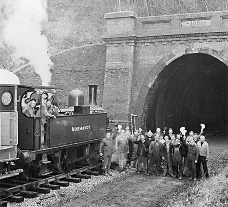
The photo shows the arrival of the rails (and locomotive 'Normandy' and track gang) through the tunnel on 5 March 1992.
1992-4: The Bluebell Railway's extension reached New Coombe Bridge in 1992. For two years this was a temporary terminus with no platform, and the simple run-round loop as shown below, just to the north of the former West Hoathly station platforms. It was not possible for passengers to alight from the trains, since one of the stipulations of the planning permission was that there should be no such facilities, thus protecting local residents from an increase in road traffic.


In 1993 the rebuilding of New Coombe Bridge was completed, allowing the construction of the railway line to continue northwards to Kingscote, which was reached early in 1994. With the opening through to Kingscote the run-round loop at New Coombe Bridge was removed and the line through the site is now a single track plain line.
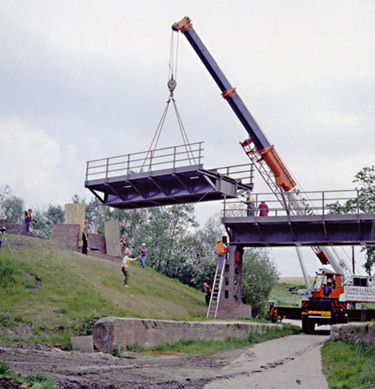
This photo shows the third and final span of the new "New Coombe Bridge" being installed on 10 May 1993. Five spans had been purchased, second hand but of very recent construction, having formed an unloading facility for aggregates arriving by rail for the construction/improvement of the A55 North Wales Expressway.
There are still no plans for passenger facilities or a platform at West Hoathly, although this may not be ruled out for the longer term, since now the extension is completed to East Grinstead the line could provide a useful public-transport facility for the residents of West Hoathly and Sharpthorne. These adjacent villages remain the only substantial population along the length of the current line, Horsted Keynes village being some considerable distance from that station.
The Subterranea Britannica's site for disused stations has a page with details, a map and photos of West Hoathly Station.
The Signalling Record Society provides a signalling diagram for West Hoathly.


Return to BRPS Home Page,
to the Timetable or to Special
Events
Track Layouts: Sheffield Park - Horsted Keynes - West Hoathly - Kingscote - Location Map & Gradient Profile
Visitor Info. -
Museum -
Trust -
Catering -
Contacts -
What's New -
Projects -
Locos -
Carriages & Wagons -
Signals -
History -
Other -
Links -
Search -
FAQ
Why not become a BRPS Member? -
Get more involved as a Volunteer
Your ideal Film/TV location?
 Copyright © Richard Salmon.
Last updated 12 February 2023 by Richard Salmon.
© Copyright BRPS. Privacy Policy
|


