Track Layouts: Sheffield Park - Horsted Keynes - West Hoathly - Kingscote - Location Map & Gradient Profile


Horsted Keynes Track Layout
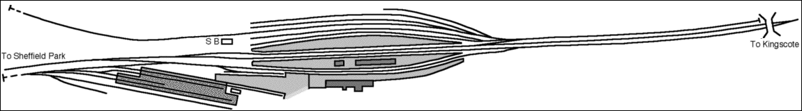
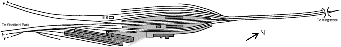
This page presents diagrams of the track layout at Horsted Keynes station on the former Lewes & East Grinstead Railway, now preserved by the Bluebell Railway. The layout of this large junction station has constantly evolved over the years, and the diagrams are snap-shots at significant stages in the development of the station site.
Platform Numbering: There is some conjecture over the original numbering of the platforms. Normal practice would have been for Platform 1 to have been adjacent to the station building on the East side (at the bottom of the diagrams). In this case the double-sided road may have been Platforms 1 and 2; the next two roads: 3 and 4; and the furthest one: Platform 5.
Whether this was indeed the case is uncertain. What is certain is that, with the furthest platform taken out of use, and then the introduction of the electric service (from a then canopy-less platform) the electric platform became number 1, and the numbering was changed to the long-standing arrangement with Platforms 3 and 4 being the double-faced road next to the booking office. For many years, in preservation, the lost platform road was known locally as "Platform 0"! With the re-signalling of Horsted Keynes being designed to include re-instatement of this platform, on 29th September 1999 the platforms were re-numbered such that this became Platform 1, and all others were re-numbered one higher, with the double-faced platform road (now "4-road") next to the booking office, becoming Platforms 4 & 5.
Siding Naming: In Bluebell ownership, the following names have evolved. In the Up Yard (west of the station, to the top of the diagram) the disused platform road was known as "0-Road", with the sidings beyond being named with impeccable logic "-1", "-2", "-3" etc. With the newest re-numbering, we shall have to wait and see whether new names evolve! Current favourites are Hudson's Bay for the short siding furthest from the platforms, and "The Cripple Siding" being the central one on which stock which is too fragile to be shunted is stored. The Ardingly spur was sometimes referred to as the "Long Siding", but is now connected up as a future running line. The line to the North on the up side was the "Up Headshunt", but with the recent change to the track layout becomes the "Up Backshunt". The Up Yard was used in LBSCR days for the storage of locomotives awaiting scrapping or repairs at Brighton, and consequently much photographed.
The Down Yard or Goods Yard (to the south-east, at the bottom left of the diagrams below) includes the "Dock", and then in the yard proper the sidings are named A, B, C, and D (the four carriage-shed roads), with E and F added more recently beyond the shed. E-road includes an inspection pit for brake adjustments on the carriages. The "Down Headshunt" is the track parallel to the line to Sheffield Park (but higher than it, since it is almost level compared to the 1-in-75 falling gradient of the running line).
The Diagrams
1910: The track layout probably changed very little between construction in 1882 and 1910. The goods "lock-up" shed in the down yard was added some time after the initial opening. The points giving entrance to the Down goods yard are a "Single Slip", enabling access from the two eastern (lower) platform roads.
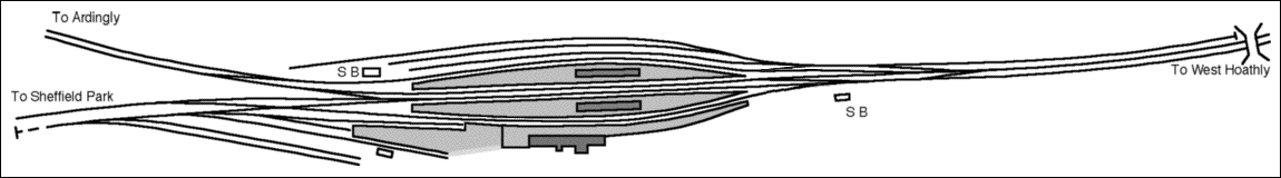
1914:In 1914 the physical junction was moved from the north end of the station to the south, in order that it could be controlled by the South Signal Box. The North Signal Box was reduced to Shunting Frame status, and the Platform 1 canopy was demolished to provide clear sight-lines from the South Box. The western-most (top of the diagram) platform road was taken out of use, re-classified as the "Up Siding", and the remaining platform roads became, from the West, "Passenger Loop", "Up" and "Down". My thanks to John Hemsley, Bert and Chris Bassett and Peter Richards for providing information for this diagram, which shows the layout as at 29th March 1914.
It is interesting to compare the above with this LB&SCR diagram showing planned alterations, which is displayed in our "Wedding Room" at Horsted Keynes - photographed by Derek Hayward.
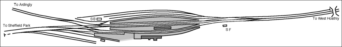
1935: The branch from Haywards Heath via Ardingly was electrified in 1935, and the track-work simplified at the South end. The Shunting Frame (former North Box) was rendered redundant thanks to revised rules on maximum lengths of manually-worked point rodding-runs which permitted the crossover and other pointwork at the North end of the station to be worked from the South Box. This 1935 track layout was essentially that which the Bluebell took over after the closure of the Ardingly branch in 1963.
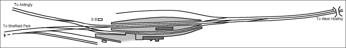
1982: The Bluebell Railway gradually converted the complex junction layout into the terminus of a single-track line from Sheffield Park. The carriage shed was built in 1971 in the former goods yard, and this 1982 diagram shows what had been achieved before work started on the northern extension.
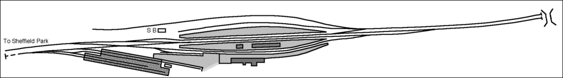
1996: The track layout at the northern end of the station was changed significantly for the initial shuttle service operating from Horsted Keynes for 3/4 mile to Horsted House Farm when the first stage of the extension opened in 1990. However, the track layout below was largely formed two years later once through trains started operating. Note also that the connection from the then platform 2 into the down goods yard, via the single slip, has been abolished, having been out of use for several years; the further development of the sidings in both the up and down yards, and the relaying of the Ardingly spur as a "long" siding.
2004: a fairly major alteration of the layout took place as part of a scheme to re-signal the station area. The first work carried out was on the access to the up yard, which has been reversed, and the dock siding was removed. In preparation for the extension of the carriage workshops, the Goods Shed was re-located to Kingscote, and the works extension is now shown. The single slip, which used to give access to the carriage yard, has been replaced by a new point on a new alignment, and the point giving access to the dock has been re-instated in its earlier position, coming off the down yard rather than the running line. All the running line points to the south of the station have been renewed on new alignments, and a point was been put in which will form the junction for a possible extension to Ardingly. This was initially connected up to the Ardingly siding, the former long siding being truncated. This provided easier access for shunting stock stored on the Ardingly formation.
At the north of the station platforms a tandem point has been installed, linking the "up" line (now known as the "loop") with platforms 1, 2 and 3. At the end of July 2000, the buffer stops at the south end of Platform 1 were removed, and the track linked up to the Ardingly line.
In the down yard, the track at the north end of "D" road was extended into the carriage works extension, and "A" road re-laid and shortened slightly as that part which was outside the old shed was brought within the new extension. In early 2002 a P-Way siding was laid off the down headshunt. In July 2002 "C" road was abolished, allowing "D" road to be slewed more centrally within the building. This provided improved working space within the new paint shop then being created at the south end of the shed. On 20th October 2002, the vounteer track gang completed the relaying of the dock road on its original alignment, using LBSCR rails and chairs.
In early 2003 the Ardingly siding was moved from the southern side of the embankment to the northern side, and reconnected to the former long siding, reversing the change outlined three paragraphs above. During the course of 2004 the new Ardingly running line from Platforms 1 & 2 was extended on the south side of the formation almost as far as the missing viaduct to provide a track to running-line standards parallel to the siding. Also, during 2004, the final phase of the reinstatement of the building under the rebuilt canopy on Platform 1-2 was constructed, and is shown.
 Currently: The OP4 project to provide a large extension to the Horsted Keynes Carriage Shed has put E-road under cover, along with a partial tram-road at the further end of the same maintenance area, and four more storage roads (F, G, H and J roads).
The very short F-road shown above had been abolished a few years before, to provide a point to relay one of the older yard points, and B-road disconnected due to the failure of that point. This was a symptom of the aging state of much of the original Victorian track layout, and the OP4 project, combined with the donation of a large quantity of second-hand pointwork in good condition and a major Infrastructure project to re-inforce the embankment and widen the apron South of the new shed, has enabled the yard layout to be completely revised, to accommodate access to the new shed space.
The accompanying diagram shows what is currently proposed, and the annotations in red show what has already been layed in, as of the end of September 2018. The transition is complicated by the need to minimise disruption of access to E road, used almost daily for access to the rolling stock maintenance facilities.

Return to BRPS Home Page,
to the Timetable or to Special
Events
Track Layouts: Sheffield Park - Horsted Keynes - West Hoathly - Kingscote - Location Map & Gradient Profile
Visitor Info. -
Museum -
Trust -
Catering -
Contacts -
What's New -
Projects -
Locos -
Carriages & Wagons -
Signals -
History -
Other -
Links -
Search -
FAQ
Why not become a BRPS Member? -
Get more involved as a Volunteer
Your ideal Film/TV location?
 Diagrams Copyright © Richard Salmon and Jon Goff.
Last updated 13 March 2020 by Richard Salmon.
© Copyright BRPS. Privacy Policy
|